Josef Müller-Brockmann’s seminal text on grid systems may need an addendum due to the discovery of a new kind of grid. (This discovery is probably not what you’re thinking, rather how you’re thinking. Let me explain.)
Grid systems guide design—they can both direct layout and direct the eye as we interpret layout. They basically help us navigate space. The navigation of physical space may rely on grid strategies too, through our internal mapping. The discovery of specialized neurons found in the entorhinal cortex of the brain seem to fire in “amazingly regular” patterns [1] suggesting that we create an internal grid of our external surroundings. Mind blowing, right?
Just last year, scientists May-Britt and Edvard Moser were awarded the Nobel Prize for their discovery of these “grid cells.” Their “active firing positions form a hexagonal pattern that spans, for each cell, the entire local space available to the animal.” [2] In other words, as lab rats explore environments, their brain dynamically graphs the area, building an internal coordinate system. Interestingly enough, this may also reveal how the brain is computing and not just sensing.
How we self-locate, navigate and even remember events in space is a complex cognitive function not yet fully understood. What is presumed is that our internal models integrate information from different types of cells: grid cells, place cells, head direction cells and border cells.
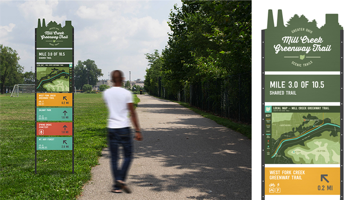
A modular wayfinding system for the Mill Creek Greenway Trail and part of the Greater Ohio Scenic Trail System proposal.
Designs by Chi Thorsen and Aly Yorio.
Grid cells, you know. Place cells are found in the hippocampus and code environments. They continually ask “where am I now” [3] and fire based on field signals (landmarks, self motion, etc.). [4] Head direction cells act like an internal compass and fire based on changes in (head) direction. And border cells, you guessed it, fire at the edges of objects and environments. (Needless to say, these descriptions serve only in proxy to more complex functions.) All together, neural firing patterns “may determine how we perceive and remember our position in the environment as well as the events we experience in that environment.” [5]
Why is this important for designers? Well, for those studying environmental graphic design (a class I recently taught at the University of Cincinnati), it’s of obvious relevance. To perceive and proceed in space is under EGD’s purview. In determining “where to locate signs, what they should say, and how they should say it” [6] shouldn’t we also be investigating “how they should think it”? In other words, context, content, communication, and cognition.
What are our cognitive maps and how do we clarify (or enhance) them? This is what Kevin Lynch explored in the book, The Image of the City. His approach gathered “material from psychology and the humanities” to investigate “how people perceive urban environments.” [7] How do people perceive environments? Inquiring minds want to know. From interviews and qualitative analysis, Lynch identified five key elements that comprised mental maps: paths, edges, districts, nodes, and landmarks. We’re all familiar with his analysis. But in a recent read, because of these new scientific discoveries, it took on new meaning for me. I wondered, do we think in concepts of “landmarks” because of place cells; “edges” because of border cells; “paths” due to head direction cells; and “districts” from grid cells? How fascinating (to consider). Does biology, then, build reality? If so, isn’t this important for design students to learn?
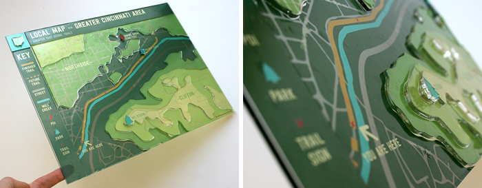
Instead of a flat map, this topographic prototype reflects Cincinnati’s hilly terrain and therefore offers more pertinent trail information. Its innovative design is made from layered acrylic with metallic clear vinyl application, modeling painted aluminum, and offers visual salience. Designs by Aly Yorio and Chi Thorsen.
Understanding how people understand space is where environmental design begins. In the field of cognitive science there is general agreement on how people comprehend space. [8] It seems our spatial knowledge is organized into three categorizes: landmark knowledge, route knowledge and survey knowledge. (The artist in me starts to think: point, line and plane.) Landmark knowledge identifies objects and associates them with places; route knowledge sequences locations; and survey knowledge is map-like, recording metric distances and interconnectedness. [9] What’s more interesting is that “this progression, from least to most complex (landmark to route to survey knowledge) is also the order in which spatial knowledge is thought to be acquired; survey knowledge representing the ultimate state of greatest familiarity with an environment and hence requiring the longest duration of attainment.” [10] (Recent theories, however, have proposed that each level is acquired in parallel.) One question remains: Can the design and sequencing of signs help build better spatial knowledge?
This sign system for the Mill Creek Greenway includes orientational, district, directional, mile-marking and identification signs. If seen systematically, they may facilitate our spatial knowledge construction. Designs by Allison Ballweg, Colleen Butler, Madison Hall, and Mary Sandmann.
EGD should really stand for “exponential” graphic design. Oh, the possibilities when you add a “z” to your Cartesian coordinate system! My students delighted in new dimensions: multi-sided design, multi-modal experiences, multi-layered messaging. Typography was gauged not only by language and legibility but also by vantage points and velocities. Measuring the difference between expert and first-time users, mapping strategies, and mobility was up for discussion. So too was neuroscience.
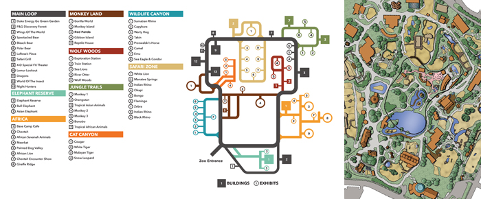
A reimagined map (left) of the Cincinnati Zoo and Botanical Garden’s original version (right). Both maps are intended to work together to offer a more comprehensive understanding of space. Designs by Mike Pinciotti with Heather Kereluik, Amanda Rapien, Kira Reed and Tony Reser.
I teach EGD like I design for it: from different perspectives. Our neuroscience “research” started with a RadioLab episode, extended to a TED Talk, and concluded with a cconference call. We encountered new terms: path integration, place signals, allocentric space, episodic memory, remapping. For those who think aerially (fifty percent of the class), an animated infographic helped ground new information. It was only after watching a video about the Kavli Institute, were we on a first name basis with May-Britt and Edvard (and their adorable rat June). Exposing students to this new topic from different perspectives, across various media, concretized knowledge quickly. Diversification was the teaching strategy.
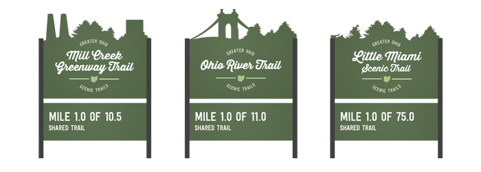
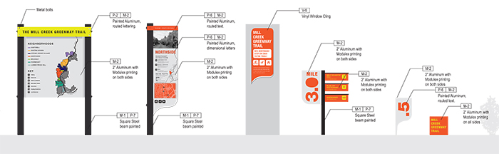
This variation on a theme illustrates the Greater Ohio Scenic Trail system; these three signs, representing different trails, both describe and differentiate each trail’s experience through their die-cut top. Designs by Chi Thorsen and Aly Yorio.
As a class, we got to thinking: What are some ways that signs or placement of signs can clarify spatial representations? Should signs communicate in terms of self-movement (steps as opposed to distances)? Should maps offer multiple representations of space (detail and distal views, hidden perspectives, predictive sequencing)? Should signs be made of multiple sensory items? Should signs be designed to act more like landmarks (offering perceptual salience)? Do they organize information in such a way so as not to tax working memory? Are they placed strategically? Or should signs be eliminated altogether, forcing exploration? All in all, our inquiries served merely “to capture ideas and to suggest how they might be developed and tested.” [11]
Whether or not you have a strong sense of direction, you can see where design is heading: inside the mind. The brain is the new frontier. Our field is changing based on discoveries in spatial and visual perception. Is the “new role of a graphic designer … to direct the cognitive and emotional processes of the audience?” [12] Only testing will tell. We previously designed signs systems. We currently design (for) a thought process. Understanding the user’s navigational needs, then, requires a meeting of the minds.
++++
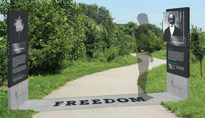
Historical site and grove markers that commemorate the path of slaves as they traveled up the Mill Creek to freedom. Designs by Katie Schirmann and Kelsey Hisek with Sarah Bielby, and Mike Pinciotti.
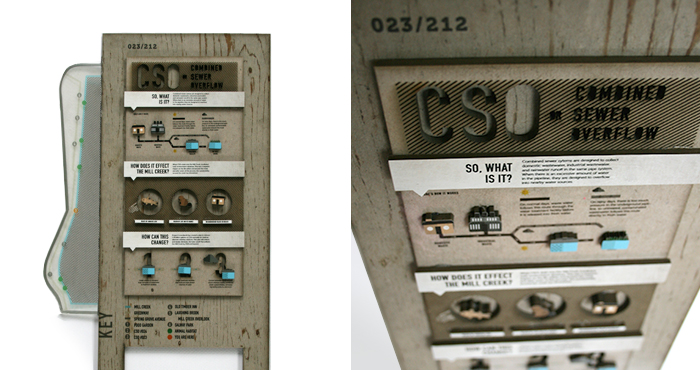
The Combined Sewer Overflow (CSO) program in Cincinnati allows raw sewer to flow into the Mill Creek during heavy rainfall. This sign system numbers CSO stations along the trail and educates patrons about its danger. The design is innovative and performs like an infographic: The prototype uses clear vinyl atop chipboard to represent recycled wood and showcases dimensional icons alongside flat graphics. A map of the trail that extends from the side, seemingly floats in space. Designs by Andria Mierzwiak and Tyler Sperry with Christina Koplyay.
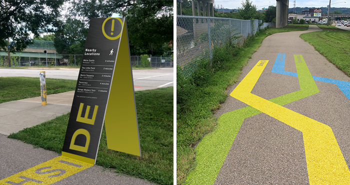
Located on the trail near the neighborhood of Northside, these safety signs (left) list local businesses in terms of walkable distances. They are strategically placed at trail junctures, can be seen from a distance, and illuminate at night. The visual system incorporates lively, yet informative pavement markings as well. Designs by Patty Johnson with John Kazior and Jacob Wells.
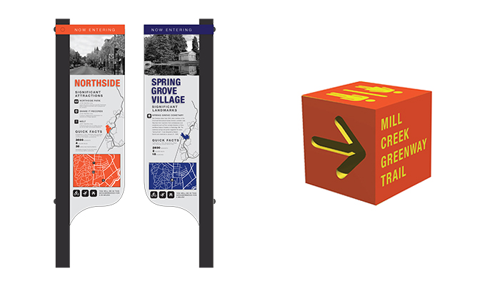
This district sign (left) shows a front and back view along with unique directional cubes (right). Designs by Allison Ballweg and Mary Sandmann with Colleen Butler and Madison Hall.
This prototype is part of a system of trail markers, made from painted metallic acrylic in order to simulate aluminum.
Designs by Tony Reser and Trent Victor with Bethany Biers and Kira Reed.
++++
[1] Neil Burgess, “How Your Brain Tells You Where You Are,” 2011
++++
[1] Neil Burgess, “How Your Brain Tells You Where You Are,” 2011
[2] May-Britt and Edvard Moser, “Crystals of the Brain,” 2011.
[3] Burgess, 2011.
[4] The 2014 Nobel Prize in Physiology or Medicine was also awarded to John O'Keefe for his work with “place cells”—initially discovered in 1971 by O’Keefe and (John) Dostrovsky.
[5] Edvard Moser, Emilio Kropff, and May-Britt Moser, “Place Cells, Grid Cells, and the Brain’s Spatial Representation System,” 2008.
[6] David Gibson, The Wayfinding Handbook: Information Design for Public Places (New York, NY: Princeton Architectural Press), 2009.
[7] Richard LeGates and Frederic Stout, The City Reader (London: Routledge, 1996).
[8] John Gero, "Studying Visual and Spatial Reasoning for Design Creativity," 2015.
[9] Ruth Dalton, Hugo Spiers, Christoph Hölscher, “Navigating Complex Buildings: Cognition, Neuroscience and Architectural Design,” 2014.
[10] Ibid.
[11] Ibid.
[12] Connie Malamed, Visual Language for Designers: Principles for Creating Graphics That People Understand (Beverly, MA: Rockport Publishers), 2009.