March 2, 2017
All Maps Lie

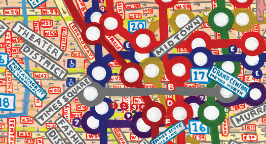
Map of Midtown Manhattan from the book Maps by Paula Scher
In the late 1950s, when I was eight and nine years old, my father spent his weekends in the basement of our small, single-story house, measuring and cutting up pieces of light green laminated board. My mother repeatedly admonished my brother and I not to bother him because he was busy constructing an important invention. My brother and I continuously made fun of the so-called invention because it appeared to be nothing more than a piece 
of cardboard with three holes cut into it. We would describe to each other the scraps of board lying around with the cutout holes and break out into a gale of laughter.
I knew that my father was something called a “ civil engineer ” and that it was different from being an engineer on a train. I was told that he was a special kind of engineer and that his specialty was photogrammetry. I couldn’t actually say the word, or explain what photogrammetry was, until I was an adult. A photogrammetric engineer studies the science of cameras. My father worked on aerial photography in the mapping division of the U.S. Geological Survey.
My father called his invention Stereo Templates. The three perfectly positioned circles that were cut into the light green laminate board functioned as a measuring device that helped correct the distortions in blown-up aerial photographs used for mapmaking.
There were giant aerial photographic maps all over our basement. They were incredibly beautiful. There were amazing maps of the Rocky Mountains that clearly detailed the majestic topography, maps of lakes and rivers in the Northeast, maps of coastlines, and detailed maps of cities. I thought they were much more beautiful than any of the artwork that my mother purchased from museum shops and displayed in our living room.
My favorite map of all was an aerial photograph of our whole neighborhood, a housing development called Oakview, in Silver Spring, Maryland. I could plainly see my house, the block I lived on (Cottrell Terrace), and where my friends Carolyn, Joan, and Susan lived. I saw my elementary school, the playground where I played kickball, the community pool, the ravine, and the woods across the street from my house, where I had a fort. I saw Hillandale (the shopping center near our neighborhood), and the shortcut there that would later become a stretch of the Capitol Beltway. I even saw the routes I would take to all of these very important places on my bicycle. Looking at that map was like looking at a picture of my entire life. Everything was there.
But my father told me that the map was distorted. He pointed out its discrepancies: an inaccurate curve of the roadway here, a shadow that blocked the proper view of our shed there, a foreshortening of Oakview Drive. I thought he was nitpicking, but he insisted that these kinds of distortions cause all kinds of problems for people building houses, roads, and bridges. “All maps are distorted, they are not literal fact.” He tried to explain lenses and what caused distortion in aerial photography. I didn’t understand him at all.
Children don’t have much capacity for nuance. For me, at the age of eight, the word “distortion” was akin to “lying”. Something was either true or false, black or white, no shades of gray. If cameras and lenses distorted maps, then they weren’t true and couldn’t be trusted. The map of Oakview was a deception, a lie, not the real place but a seductive impression of it. I was taken in and outraged at the utter dishonesty of it. And yet, I still wanted to look at it and recall the places I knew, the way I could hear a bedtime story over and over again, knowing that it wasn’t real, but trusting in it anyway because it was so familiar.
I remember an even more persuasive example from my father about how maps lie. I was a bit older, and we were taking a road trip from Washington, DC, to New York. My father had picked up a new road map at an Esso station. He was searching for an alternate route through a city, which I think was Baltimore. My father complained that the new map had specifically highlighted roads that contained Esso stations with a thicker bright yellow than other roads. One might assume that these highlighted roads were express routes through the city, but they weren’t. It was a deliberate distortion. They lied.
Years later, as a young adult, I began working as a professional graphic designer. My job was (and still is) to organize and layout other people’s information. I am completely aware of the distortions that can inadvertently occur in the process of editing, designing, and publishing texts. Articles are cut to fit into specific formats, and sometimes the cuts alter meaning. Hierarchies are created to help readers navigate texts, sometimes distorting the emphasis of specific content. Pull quotes (those sexy excerpts from an article that are blown out of scale to entice readers) can mislead by making the article appear to be about something different. Info graphics make an opinionated article appear scientific, and are more and more frequently appearing as unbiased stand-alone data, often disguising the dogmatic intent of an author. To make matters worse, the blogosphere completely democratizes such distortions. Anyone 
can make them, and they do.
Today, for example, the technology that powers Google Maps would be impossible without the ability to correct the distortions in aerial photography using devices like stereo templates. Yet distortions always exist, and you can always find them in places you know well: the mistaken curve, an odd foreshortening, something disappearing into shadow. Someone has decided what information should be put in or left out. Someone has determined the hierarchy of the information. And when you don’t know the place very well, you forget about the distortions; you suspend belief, even though you know the maps lie. You believe them as literal fact.
In 1959, my father received a small cash award from the U.S. government for his Stereo Templates in return for the patent. He was promoted to the Coordinator of Nation’s Mapping and held that position until he retired in the early 1970s. His new post was a management position. He never invented anything again.
I began painting maps to invent my own complicated narrative about the way I see and feel about the world. I wanted to list what I know about a place from memory, from impressions, from media, and from general information overload. They are paintings of distortions.
The above text by Paula Scher, is from the introduction of her new book Maps (Princeton Architectural Press, 2011) and has been reprinted here with the author’s permission. This essay was originally published on Design Observer in November 2011.
Observed
View all
Observed
Share on Social
By Paula Scher
 Paula Scher is a partner in the New York office of Pentagram, a recipient of the AIGA Medal, and the author of Make It Bigger.