Via Wikipedia
The midterm elections are almost upon us and even the most casual observers of political news can guess their larger outcome: while voter opinion of Congress is incredibly low, voters will send an overwhelming number of incumbents back to their jobs. To the extent that any surprises emerge, they'll most likely be a side effect of low turnout from an electorate that feels unhappy and unempowered.
There are many reasons for this. One is gerrymandering.
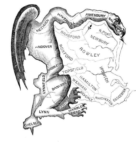
“Gerrymandering” refers to drawing political districts along partisan lines. As I noted in an earlier piece, an early nineteenth-century illustration attributed to Elkanah Tisdale envisioned a weirdly drawn state senate district (benefiting then-Massachusetts governor Eldbridge Gerry) as a salamanderesque creature. The Gerrymander lives on to this day as a potent shorthand visualization of dubious politics—arguably one of the most successful political illustrations ever.
In that earlier piece I lamented the generally bland or even off-putting visualizations of modern gerrymanders—a sad state of affairs given that gerrymandering is probably a worse problem now than it was in Tisdale’s time. And I mused that perhaps there was an opportunity to revive the spirit of that classic gerrymander illustration to visually communicate its contemporary descendants.
Well, now we have done just that: Welcome to Spawn of Gerrymander.
Over the course of the week, this series will present graphic visualizations of six gerrymandered U.S. Congressional districts, created by six dynamite illustrators: Joe Alterio, Steve Brodner, Lisa Congdon, Jennifer Daniel, Oliver Munday, and Leif Parsons.
The challenge of really making us see how ridiculous these districts look gave rise to completely distinct results. But taken together, they are even more powerful. If these visualizations don’t drive home just how absurd partisan districting practices have become, I don’t know what will.
So please check in here (or on Twitter or Facebook: #SpawnOfGerrymander) through the week as we post these pieces.
About the Districts
I’m no election wonk, so the process of choosing potential districts to illustrate began with conversations with actual experts, who steered me away from trying to rank the most gerrymandered districts—partly because gerrymandering has many motivations. Sometimes districts get contorted to protect an incumbent, or his or her party. But sometimes they take on weird shapes because partisan mapmakers seek to “pack” a district with as many (likely) rival voters as possible, opening up more opportunities elsewhere.
Both parties, it almost goes without saying, have been guilty of these practices. And not surprisingly, there is often a partisan undertone to critical writing about gerrymandering. So for this project, I started with some very useful reports (the most recent from 2012, building on research first published in 2006) from a “geographic data, geospatial analysis” firm called Azavea (which others have recognized for its contributions to this subject). I won’t bore you with the details, but the firm’s research drew on a variety of methodologies designed to evaluate the “compactness” of congressional districts (correcting for geographic features like bodies of water and so on) to arrive at various rankings of—to shift to the vernacular—districts that just look weird.
From there, I spent a lot of time reading up on individual districts, as well as an array of journalistic assessments and lists of egregious contemporary gerrymandering. Along the way, I was repeatedly reminded that gerrymandering is by no means the only issue challenging our political system: polarization has a variety of causes, some electoral shifts can be partly explained by actual demographic/geographic patterns; and voting rights can be watered down by laws as much as by maps. None of that, however, justifies the obvious contortion of many congressional districts for purely political reasons. To paraphrase an academic public policy expert in this helpful Washington Post video, representatives effectively get to choose their voters rather than the other way around.
I ended up with a set of possibilities that I presented to the illustrators, basically letting them settle on the shapes that caught their eye. The sad truth is I was able to offer them a considerable array of choices.
Actually, that’s not just a sad truth, it’s a vital truth.
The point here is not to demonize any particular district. It is to make the case that the Spawn of Gerrymander are alive, thriving—and distressingly numerous. And it doesn’t have to exist. Some states have turned over district-drawing to nonpartisan authorities (read more about that here and here; Iowa frequently comes up as a positive example) and it is then, so far as I can tell, that gerrymanders rarely occur.
But many states give control to (partisan-controlled) state legislative bodies and the like—and, to the surprise of no one, that’s where the most nonsensical district shapes emerge. The upshot is that we could have done this project with six completely different districts, or six different ones again, and so on.
And that, of course, is precisely the problem. Can you see it? Well, you will.
Here’s what’s coming up:
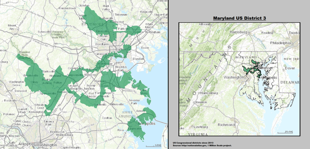
Joe Alterio interprets Maryland’s Third Congressional District
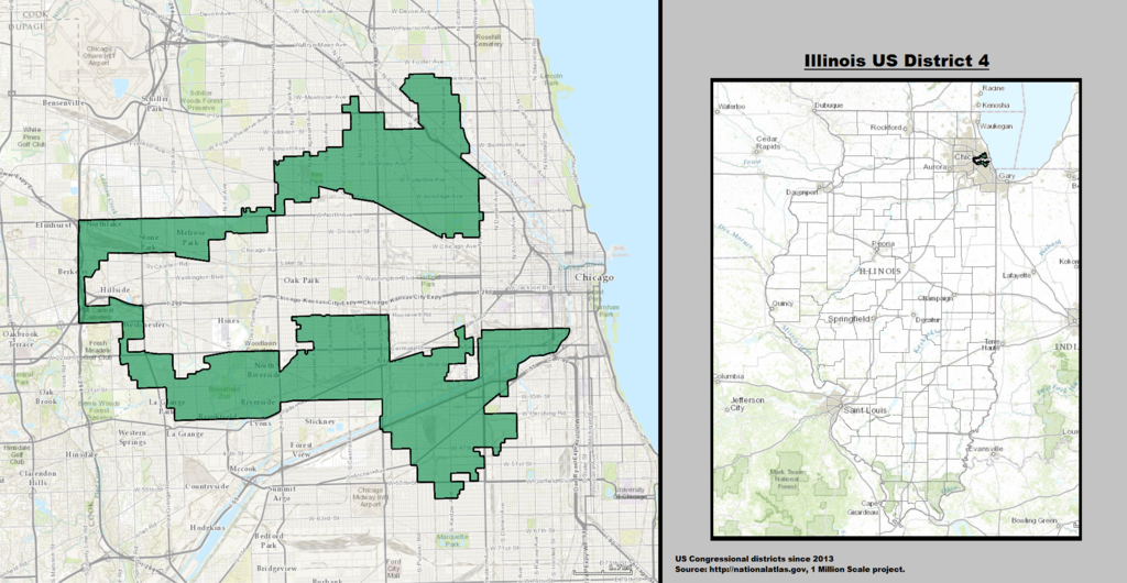
Leif Parsons interprets Illinois’ Fourth Congressional District
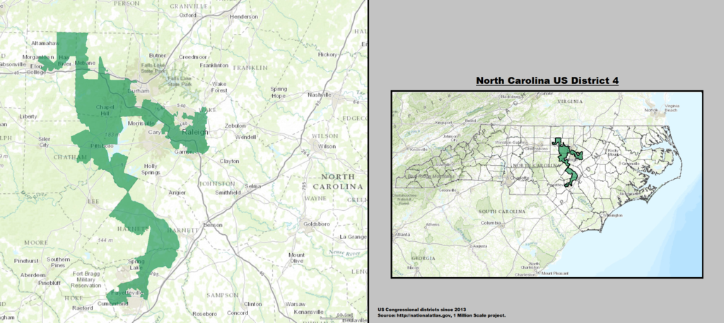
Lisa Congdon interprets North Carolina’s Fourth Congressional District
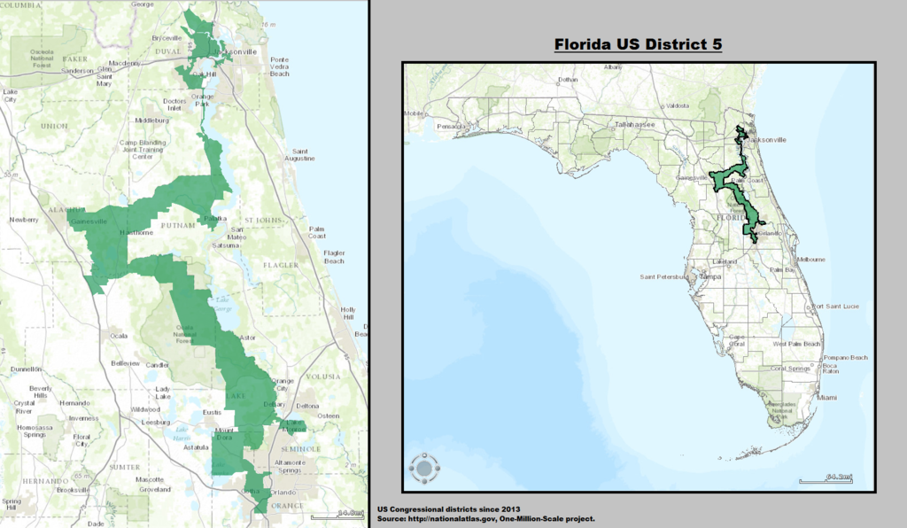
Oliver Munday interprets Florida’s Fifth Congressional District
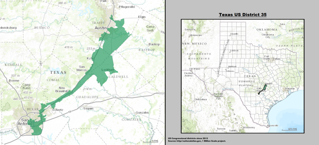
Jennifer Daniel interprets Texas’ Thirty-Fifth Congressional District
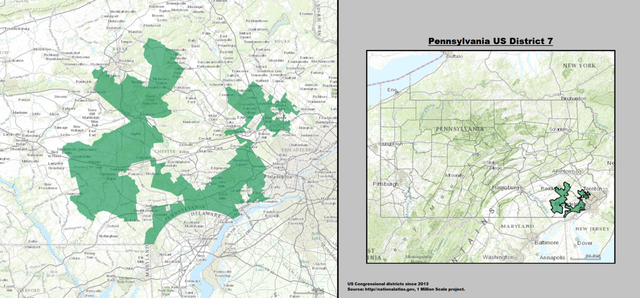
Steve Brodner interprets Pennsylvania’s Seventh Congressional District
This project has been made possible in large part thanks to a grant from The Awesome Foundation’s Awesome Without Borders chapter. Thank you! Thanks also to Erin Mayes of EmDash, and writer Michael Silverberg—as well as the editors of Design Observer, and all the participating illustrators.


Comments [1]
10.16.14
09:28