
John Foster|Accidental Mysteries
September 26, 2014
Photogrammers at Yale
A team at Yale University has developed an innovative web-based platform for organizing, searching, and visualizing the 170,000 photographs created by the United State’s Farm Security Administration and Office of War Information (FSA-OWI) between 1935 and 1945. The original effort was led by the legendary Roy E. Stryker and resulted in an unprecedented look at American society during the Great Depression and the war years. The collection of negatives and prints is held by The Library of Congress and includes now-iconic photographs by Walker Evans, Dorathea Lange, Gordon Parks, and Ben Shahn.
The platform is aptly called Photogrammar. It includes an interactive map of the United States that plots the FSA photographs using historical data for county, state, national, and census data over the ten-year period. This site is the photo historian’s dream and illustrates some commendable information design.
After receiving a grant from the NEH, the site was created by a dedicated team at Yale led by Laura Wexler, who has a joint appointment in American Studies and Women’s, Gender and Sexuality Studies. She is also the founder and director of the Photographic Memory Workshop.
Wexler says that the Photogrammar site “plans to associate the photographs with other kinds of material, such as the famous ‘shooting scripts’ of the FSA and the papers of its director, Roy Stryker.” Photogrammar is a mind-boggling site of navigational clarity and information, allowing public access to date of approximately 90,000 photographs that can be accessed by photographer, date, and place.
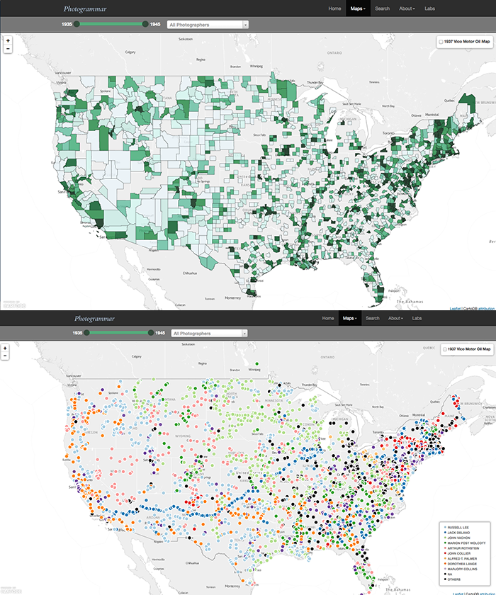
An initial search of MAPS brings up ALL PHOTOGRAPHERS between the years of 1935 to 1945, and as you can see in the first map, this is searchable by counties, or by seeing the the placement of dots across the United States. This illustration both choices you might choose

A specific search for Dorothea Lange show all the counties she visited within that ten year period of time. If you were to click on the county of Malheur, Oregon you will see that there are 216 photographs to view by clicking further.
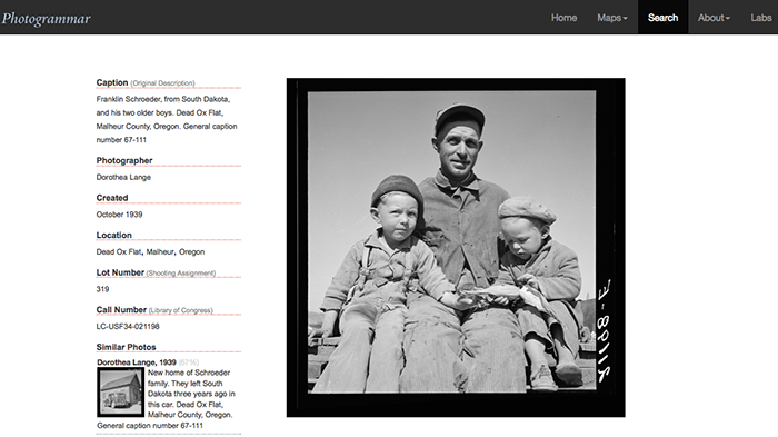
Photo by Dorothea Lange, from Malheur County: Caption reads: Franklin Schroeder, from South Dakota, and his two older boys. Dead Ox Flat, Malheur County, Oregon. October 1939. General caption number 67-111.
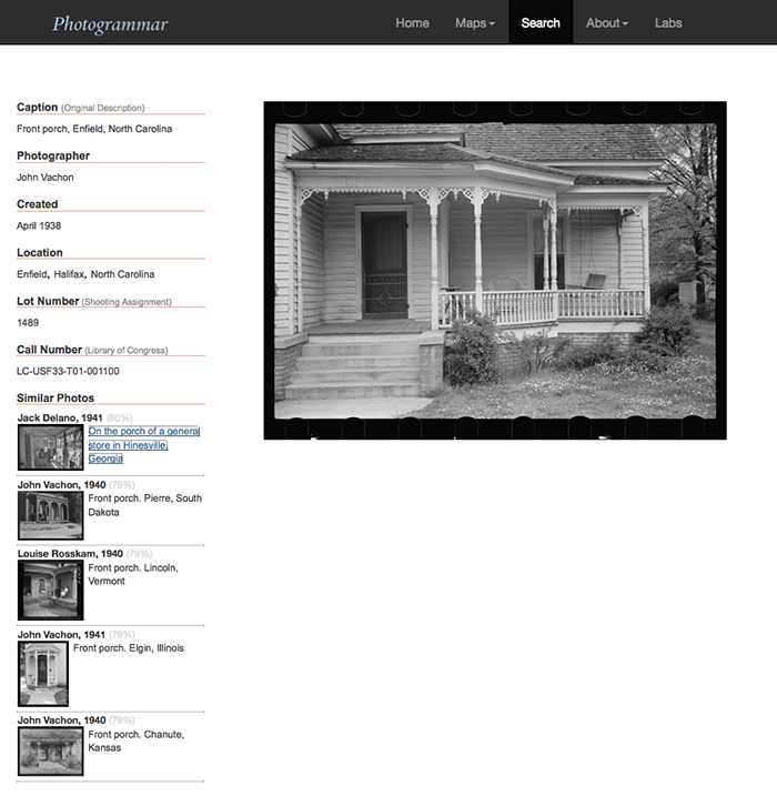
A photo pull of a photograph by John Vachon take in April 1938.

An image by the great Walker Evans of a small market in Winston-Salem, NC in 1935.

Full view of the Walker Evans image.
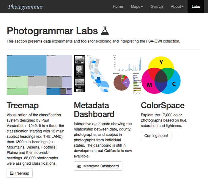
The landing page for the Protogrammar Labs, which includes a Treemap,Meta Dashboard, and area to come called ColorSpace, where you can explore the 17,000 color photographs based on hue, saturation, and lightness.
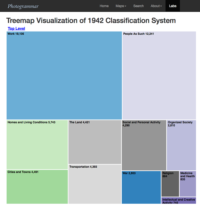
Treemaps is the visualization of the classification system designed by Paul Vanderbilt in 1942. It is a three-tier classification starting with 12 main subject headings (ie. THE LAND), then 1,300 sub-headings (ie. Mountains, Deserts, Foothills, Plains) and then sub-sub headings. 88,000 photographs were assigned classifications.

The Metadata Dashboard is still under construction, but does give deep information for the state of California. The dashboard shows the relationship between date, county, photographer, and subject in photographs from individual states.

This map overlays a 1937 Vico Motor Oil roadmap across the United States, showing the roadways of travel, and before the interstate highway system. The black dots represent the place photographer Carl Mydans took photographs, all clickable to reveal the images for inspection.
Observed
View all
Observed
By John Foster
Related Posts
Accidental Mysteries
John Foster|Accidental Mysteries
The Remarkable Mr. Deeds
.jpg)
John Foster|Accidental Mysteries
Doug Rickard: N. A.
Accidental Mysteries
John Foster|Accidental Mysteries
An Archive of Czech Film Posters

Accidental Mysteries
John Foster|Accidental Mysteries
A Visual History of Lunchboxes
Recent Posts
Mine the $3.1T gap: Workplace gender equity is a growth imperative in an era of uncertainty A new alphabet for a shared lived experience Love Letter to a Garden and 20 years of Design Matters with Debbie Millman ‘The conscience of this country’: How filmmakers are documenting resistance in the age of censorshipRelated Posts

Accidental Mysteries
John Foster|Accidental Mysteries
The Remarkable Mr. Deeds
.jpg)
John Foster|Accidental Mysteries
Doug Rickard: N. A.

Accidental Mysteries
John Foster|Accidental Mysteries
An Archive of Czech Film Posters

Accidental Mysteries
John Foster|Accidental Mysteries

 John Foster and his wife, Teenuh, have been longtime collectors of self-taught art and vernacular photography. Their collection of anonymous, found snapshots has toured the country for five years and has been featured in Harper’s, Newsweek Online and others.